
Levee Inspections Underway As Columbia River Water Levels Rise to Minor Flood Stage
![]()
Regular Levee Inspections Underway
As Columbia River Water Levels Rise to Minor Flood Stage
Local flood safety agencies work to reduce flood risk
FOR IMMEDIATE RELEASE
June 13, 2022
Portland, OR – Rising water levels on the Columbia River prompted the Multnomah County Drainage District (MCDD) to activate its Incident Management Team (IMT) and begin Enhanced Operations at noon on Friday, June 10, 2022.
MCDD operates and maintains the levees and pump stations that reduce the risk of flooding along the lower Columbia River and Columbia Slough from North Portland through Gresham, Fairview, and Troutdale. This flood safety system is maintained by four separate drainage districts that contract operations to MCDD. The system includes 27 miles of levees, 12 pump stations, and 45 miles of slough, ditches, pipes, and culverts, which reduce the risk of flooding to a 13,000-acre area that includes the Portland International and Troutdale Airports, parts of three Interstate highways, over 2,500 businesses and 59,000 jobs, about 7,500 residents, and 2,000 acres of parks and natural areas.
While in Enhanced Operations, MCDD monitors water levels, conducts regular inspections of the levees, coordinates with partner agencies like the U.S. Army Corps of Engineers and City of Portland Bureau of Emergency Management, and communicates with property owners and others who live and work in the low-lying managed floodplain.
According to data provided by the National Oceanic & Atmospheric Agency’s Northwest River Forecast Center, Columbia River levels at the Vancouver River Gauge, located near the Interstate 5 Bridge on the Washington side, are currently at 16.06 feet (NGVD29), and they are expected to remain at or around this level until Wednesday, June 15, when they will slowly recede. At 16 feet, the river is at minor flood stage, and it is not anticipated to reach moderate or major flood stages, which begin at 20 and 25 feet. At current levels, no major damages are anticipated, however, the lowest lying properties on the river side of the levees may experience some flooding.
MCDD is working with Cascadia Behavioral Health to communicate additional flood risk to anyone camping on the riverward side of the levee where there is currently the most risk. MCDD also recommends that residents of floating homes, marina operators, and anyone with a dock on the Columbia River secure any loose items so they do not float away and do damage to the levees.
MCDD staff have also reached out to the US Army Corps of Engineers dam operations team and will continue to coordinate as needed until the high water recedes. This high-water event is the result of melting snowpack from the mountains further up in the Columbia basin combined with heavy rains over the weekend. MCDD will continue to monitor the levees for signs of structural issues like ponding or erosion and will report unanticipated or significant changes to community members and members of the press. People who live and work in the leveed area are encouraged to report anything unusual like ponding or erosion to MCDD at 503-281-5675 or [email protected]. Additional information is available online at:
- National Weather Service, Northwest River Forecast Center, Vancouver Gauge: https://water.weather.gov/ahps2/hydrograph.php?wfo=pqr&gage=vapw1&hydro_type=2
- MCDD website: mcdd.org
- MCDD Facebook: https://www.facebook.com/MCDDfloodprotection/
- Twitter: https://twitter.com/MCDDorg
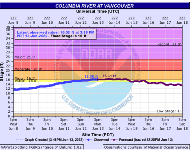
Photo Credit: National Oceanic & Atmospheric Agency, Northwest River Forecast Center
Description: As of June 13, 2022, Columbia River water levels at the Vancouver Columbia River Gauge are just above 16 feet, which is considered “minor flood stage.”
##
Multnomah County Drainage District (MCDD) and three other drainage districts (Peninsula Drainage District #1, Peninsula Drainage District #2, and Sandy Drainage Improvement Company) reduce the risk of flooding along the south shore of the Columbia River in urban Multnomah County, Oregon. The four districts collectively extend from the edge of Smith & Bybee Lakes on the west to the Sandy River on the east. Together, the districts reduce flood risk along the lower Columbia River and Columbia Slough by operating and maintaining 27-miles of levees, 12 pump stations, and 45 miles of slough, pipes, ditches, culverts, and other conveyances.
For more information, visit www.mcdd.org.
No Comments
Sorry, the comment form is closed at this time.