[pofo_section_heading pofo_heading_type=”heading-style4″ heading_preview_image=”heading-style4″ pofo_text_transform=”text-uppercase” pofo_title_font_weight=”600″ pofo_title_element_tag=”h4″ pofo_heading=”MANAGING OUR LEVEES IN A POST KATRINA WORLD” pofo_title_color=”#d16149″ pofo_title_font_size=”20px” css=”.vc_custom_1556811335846{padding-bottom: 5px !important;}”]
After Hurricane Katrina in 2005, the Federal Emergency Management Agency (FEMA) and US Army Corps of Engineers (USACE) completely overhauled the federal safety standards for levees, including significantly increasing what’s required of local levee managers.
To prove that the local levee system meets federal standards, the Levee Ready Columbia partners funded the completion of the first ever comprehensive geotechnical assessment of the levee system. The full investigation took about five years and cost about $5 million to complete.
[pofo_section_heading pofo_heading_type=”heading-style4″ heading_preview_image=”heading-style4″ pofo_text_transform=”text-uppercase” pofo_title_font_weight=”600″ pofo_heading=”WHAT WE FOUND” pofo_title_color=”#d16149″ pofo_title_font_size=”20px” css=”.vc_custom_1556673770926{padding-bottom: 5px !important;}”]
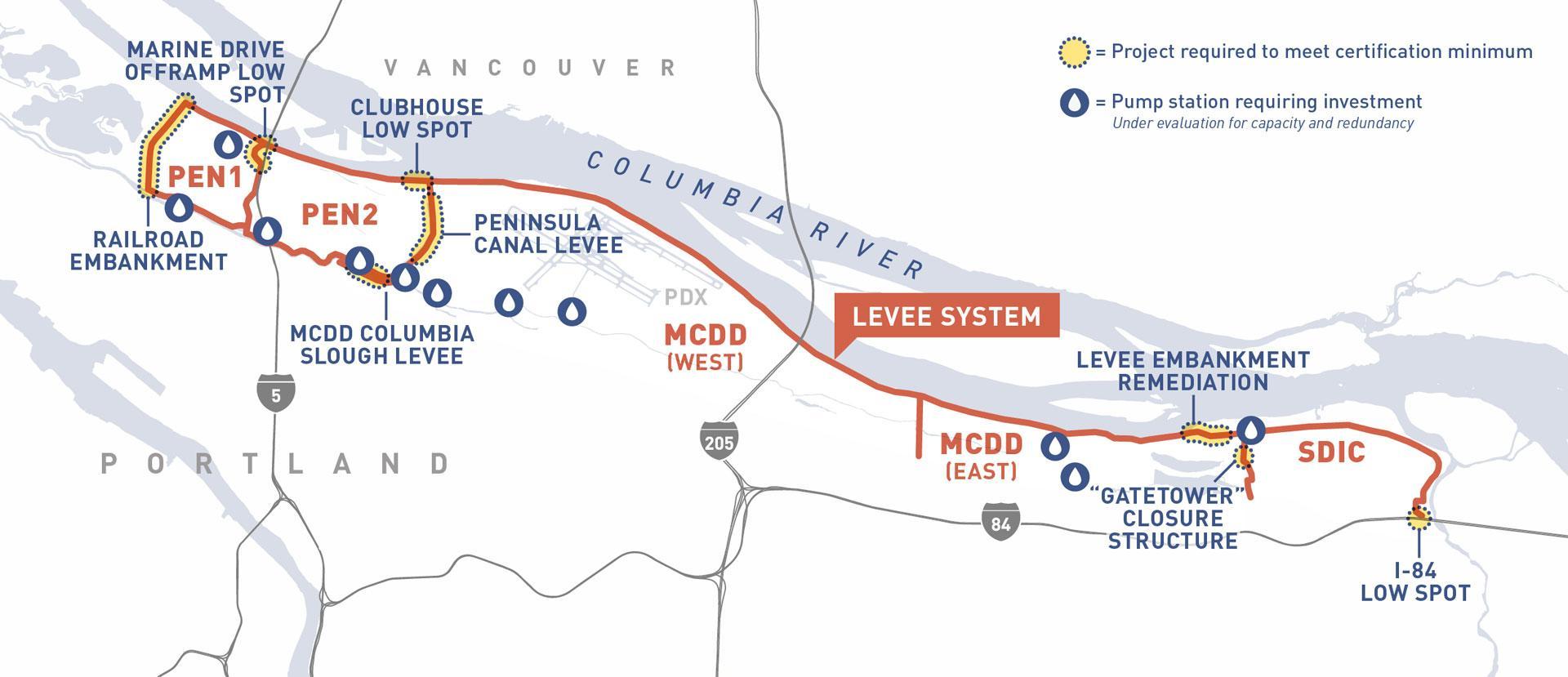
Although the investigation showed that the levees are in fairly good shape, the following problem areas were identified where the levee system does not currently meet minimum federal safety standards.
[pofo_accordion pofo_accordion_style=”accordion-style2″ accordion_preview_image=”accordion-style2″ pofo_accordion=”%5B%7B%22pofo_accordion_title%22%3A%22The%20railroad%20embankment%20on%20the%20western%20end%20of%20PEN%201%20%22%2C%22pofo_content%22%3A%22%3Cp%3EThe%20railroad%20embankment%2C%20which%20is%20a%20railroad%20trestle%20that%20has%20been%20filled%20with%20non-compacted%20earth%2C%20makes%20up%20the%20western%20edge%20of%20the%20PEN%201%20system.%20Although%20it%20functions%20as%20a%20part%20of%20the%20levee%20system%2C%20the%20embankment%20was%20not%20engineered%20to%20function%20perform%20as%20a%20levee.%20%20During%20the%201948%20Vanport%20Flood%2C%20it%20was%20unable%20to%20hold%20back%20the%20floodwaters%20and%20ultimately%20collapsed%20under%20the%20pressure%2C%20flooding%20the%20City%20of%20Vanport%20and%20leading%20to%20breaches%20in%20three%20out%20of%20four%20of%20the%20adjacent%20districts.%20Seventy%20years%20later%2C%20this%20is%20still%20the%20area%20of%20most%20uncertainty%20within%20the%20system.%20%3C%2Fp%3E%5Cn%3Cp%3E%3Cimg%20class%3D%5C%22alignright%20wp-image-22239%5C%22%20src%3D%5C%22%2Fwp-content%2Fuploads%2F2019%2F03%2FRailroadEmbankment.jpg%5C%22%20alt%3D%5C%22a%20Railroad%20Embankment%5C%22%20width%3D%5C%22500%5C%22%20height%3D%5C%22333%5C%22%20%2F%3EAlthough%20the%20embankment%20was%20originally%20constructed%20in%201907%20for%20rail%20transport%2C%20it%20later%20came%20to%20be%20considered%20a%20part%20of%20the%20levee%20system.%20%20The%20embankment%20was%20rebuilt%20after%20the%201948%20flood%20but%20was%20not%20constructed%20to%20the%20same%20standards%20as%20other%20sections%20of%20the%20levee.%20Instead%2C%20the%20railroad%20built%20a%20temporary%20trestle%20to%20restore%20service%2C%20which%20was%20later%20filled%20in%20with%20dredged%20material%20to%20complete%20the%20embankment.%20In%201972%2C%20PEN%201%20reached%20an%20agreement%20with%20BNSF%20and%20Union%20Pacific%20%E2%80%93%20the%20railroad%20companies%20that%20own%20the%20embankment%20%E2%80%93%20allowing%20the%20drainage%20district%20to%20build%20a%20maintenance%20road%20and%20add%20some%20fill.%20At%20the%20same%20time%2C%20the%20Army%20Corps%20placed%20a%20sand%20blanket%20on%20the%20eastern%20slope%20to%20increase%20stability.%20These%20improvements%2C%20however%2C%20were%20not%20enough%20to%20qualify%20the%20embankment%20as%20a%20levee.%20%20%3C%2Fp%3E%5Cn%3Cp%3EDuring%20the%20recent%20technical%20investigation%2C%20Levee%20Ready%20Columbia%20and%20the%20drainage%20districts%20attempted%20to%20reach%20an%20agreement%20with%20BNSF%20and%20Union%20Pacific%20to%20gain%20access%20to%20the%20site%20to%20assess%20the%20conditions%20of%20the%20embankment.%20%20%3C%2Fp%3E%5Cn%3Cp%3EUnfortunately%2C%20LRC%E2%80%99s%20engineers%20were%20not%20granted%20access%20to%20the%20center%20section%20and%20the%20necessary%20analysis%20has%20not%20been%20completed.%20Historic%20documents%20and%20samples%20taken%20near%20the%20railroad%20property%20suggest%20that%20the%20embankment%20does%20not%2C%20meet%20stability%20and%20seepage%20standards%20and%20that%20significant%20improvements%20would%20need%20to%20be%20made%20to%20bring%20the%20embankment%20up%20to%20levee%20design%20standards.%20%3C%2Fp%3E%22%7D%2C%7B%22pofo_accordion_title%22%3A%22The%20PEN%201%20Cross-Levee%20near%20the%20I-5%20and%20Marine%20Drive%20interchange%22%2C%22pofo_content%22%3A%22%3Cp%3EA%20portion%20of%20Interstate%205%20sits%20on%20an%20embankment%20that%20forms%20the%20cross-levee%20between%20PEN%201%20and%20PEN%202.%20%20Two%20low%20spots%20have%20been%20identified%20near%20the%20I-5%20interchange%20at%20Marine%20Drive%2C%20one%20that%20is%20too%20low%20by%20four%20inches%20and%20another%20that%20is%20low%20by%2016%20inches%20short%20of%20certification%20standards.%20Certification%20standards%20require%20levees%20to%20have%20three%20feet%20of%20freeboard%20above%20the%201%25%20annual-chance-flood.%20-ACE%20%20Freeboard%20is%20the%20vertical%20distance%20between%20the%20expected%20elevation%20of%20a%20100-year%20flood%20and%20the%20top%20of%20the%20levee.%20FEMA%20requires%20at%20least%203%20feet%20between%20the%20flood%20elevation%20and%20the%20top%20of%20the%20levee%20to%20%20Freeboard%20provides%20a%20%E2%80%9Cfactor%20of%20safety%E2%80%9D%20to%20accommodate%20additional%20flood%20heights%20and%20wave%20wash.%20These%20low%20spots%20will%20need%20to%20be%20elevated%20to%20reach%20certification%20standards.%20%20%3C%2Fp%3E%5Cn%3Cp%3E%3Cb%3EA%20note%20on%20cross%20levees%3A%20%3C%2Fp%3E%3C%2Fb%3E%5Cn%3Cp%3EAlthough%20some%20of%20the%20cross-levees%20align%20with%20the%20boundaries%20of%20the%20drainage%20districts%2C%20the%20cross-levees%20were%20never%20intended%20to%20be%20political%20boundaries.%20Instead%2C%20they%20were%20originally%20designed%20and%20constructed%20to%20create%20additional%20flood%20protection%20within%20the%20system.%20If%20one%20section%20of%20the%20system%20were%20to%20flood%2C%20the%20cross-levees%20create%20a%20barrier%20to%20reduce%20the%20risk%20of%20flooding%20in%20other%20sections%20of%20the%20system.%20While%20the%20cross-levees%20provide%20additional%20protection%2C%20no%20levee%20can%20ever%20completely%20eliminate%20the%20risk%20of%20flooding%20in%20historic%20floodplains.%20East-to-west%2C%20cross%20levees%20are%20found%20between%20SDIC%20and%20MCDD%20near%20NE%20223rd%20Avenue%3B%20at%20NE%20142nd%20Ave.%20dividing%20MCDD%20into%20two%20sections%3B%20near%20NE%2033rd%20Ave.%20dividing%20MCDD%20and%20PEN%202%3B%20and%20along%20Denver%20Ave.%20and%20I-5%20dividing%20PEN%202%20and%20PEN%20%201.%20%3C%2Fp%3E%22%7D%2C%7B%22pofo_accordion_title%22%3A%22A%20section%20of%20the%20Columbia%20River%20Levee%20at%20the%20Northeast%20Corner%20of%20PEN%202%22%2C%22pofo_content%22%3A%22%3Cp%3EAbout%20300%20feet%20of%20the%20levee%20along%20Marine%20Drive%20in%20the%20northeast%20corner%20of%20PEN%202%20%E2%80%93%20just%20to%20the%20west%20of%20NE%2033rd%20Avenue%20and%20to%20the%20north%20of%20the%20Columbia%20Edgewater%20Country%20Club%20%E2%80%93%20ranges%20from%201%20to%206%20inches%20short%20of%20the%20required%20elevation.%20%3C%2Fp%3E%5Cn%3Cp%3EFollowing%20a%20structure%20fire%20in%20this%20location%2C%20the%20site%20was%20cleared%20and%20graded%20to%20remove%20the%20foundation%20of%20the%20building%2C%20which%20caused%20these%20low%20spots%20that%20will%20need%20to%20be%20elevated%20to%20meet%20certification%20standards.%20%3C%2Fp%3E%22%7D%2C%7B%22pofo_accordion_title%22%3A%22The%20Peninsula%20Drainage%20Canal%20between%20PEN%202%20and%20MCDD%20%22%2C%22pofo_content%22%3A%22%3Cp%3EThe%20Peninsula%20Drainage%20Canal%20levee%20between%20PEN%202%20and%20MCDD%20is%20too%20narrow%20and%20the%20levee%20walls%20on%20the%20eastern%20bank%20are%20too%20steep.%20The%20level%20of%20water%20in%20the%20canal%20is%20too%20low%2C%20which%20can%20cause%20stability%20issues%20resulting%20in%20large%20amounts%20of%20erosion%2C%20which%20can%20ultimately%20cause%20failure.%20%20Additionally%2C%20the%20original%20PEN%202%20levee%20on%20the%20western%20bank%20of%20the%20canal%20is%20unofficially%20decommissioned%2C%20which%20needs%20to%20be%20addressed.%20%20%3C%2Fp%3E%5Cn%3Cp%3EThis%20canal%20is%20designated%20as%20a%20Special%20Habitat%20Area%20by%20the%20Oregon%20Department%20of%20Fish%20%26%20Wildlife%20as%20home%20to%20multiple%20protected%20species%20of%20turtles.%20%3C%2Fp%3E%22%7D%2C%7B%22pofo_accordion_title%22%3A%22A%20section%20of%20the%20Columbia%20Slough%20levee%20in%20MCDD%20%22%2C%22pofo_content%22%3A%22%3Cp%3EPrevious%20high-water%20events%20have%20caused%20erosion%20and%20other%20sloughing%20on%20the%20waterward%20side%20of%20the%20Columbia%20Slough%20levee%20in%20MCDD.%20%20As%20a%20result%2C%20the%20levee%20no%20longer%20meets%20structural%20requirements%20for%20certification%20and%20may%20need%20to%20be%20repaired.%20The%20interior%20elevations%20may%20allow%20for%20minimal%20remediation%20to%20adequately%20reduce%20the%20risk%20of%20failure%20in%20this%20section.%20%3C%2Fp%3E%22%7D%2C%7B%22pofo_accordion_title%22%3A%22A%20section%20of%20the%20Columbia%20River%20Levee%20in%20MCDD%22%2C%22pofo_content%22%3A%22%3Cp%3EA%20section%20of%20the%20primary%20levee%20along%20the%20Columbia%20River%20in%20MCDD%20has%20suffered%20erosion%20and%20damages%20caused%20by%20extensive%20animal%20burrowing%2C%20over-steepened%20slopes%2C%20and%20excessive%20vegetation%20that%20will%20need%20to%20be%20remediated%20to%20meet%20certification%20standards.%20%3C%2Fp%3E%5Cn%3Cp%3EThis%20location%20meets%20certification%20minimums%20as%20the%20landward%20side%20of%20the%20levee%20is%20robust%2C%20but%20the%20waterward%20side%20requires%20remediation%20to%20keep%20sections%20near%20Marine%20Drive%20from%20sloughing.%20%3C%2Fp%3E%22%7D%2C%7B%22pofo_accordion_title%22%3A%22The%20Gate%20Tower%20Closure%20Structure%20between%20MCDD%20and%20SDIC%20%22%2C%22pofo_content%22%3A%22%3Cp%3E%3Cimg%20class%3D%5C%22alignright%20wp-image-22238%5C%22%20src%3D%5C%22%2Fwp-content%2Fuploads%2F2019%2F03%2FGateTower-300×193.jpg%5C%22%20alt%3D%5C%22Gate%20Tower%5C%22%20width%3D%5C%22500%5C%22%20height%3D%5C%22321%5C%22%20%2F%3EThe%20%E2%80%9CGate%20Tower%E2%80%9D%20structure%20along%20NE%20223rd%20Avenue%20on%20the%20west%20side%20of%20the%20MCDD%20and%20SDIC%20cross%20levee%20is%20no%20longer%20functional.%20This%20facility%20operates%20a%20tide%20gate%20closure%20structure%20on%20dual%2042-inch%20pipes%20that%20connects%20the%20two%20districts%20through%20the%20cross%20levee.%20In%202015%2C%20divers%20inspected%20the%20tide%20gate%20and%20found%20that%20it%20is%20partially%20blocked%20and%20inoperable.%20Additionally%2C%20the%20physical%20conditions%20of%20the%20tower%20structure%20is%20so%20unsafe%2C%20it%20can%20no%20longer%20be%20accessed%20by%20operations%20staff%2C%20meaning%20the%20valve%20structure%20cannot%20be%20operated.%20%3C%2Fp%3E%5Cn%3Cp%3EFlow%20control%20and%20closure%20structures%2C%20like%20this%20one%2C%20are%20used%20throughout%20the%20system%20to%20provide%20interior%20drainage%20and%20control%20the%20flow%20of%20water%20inside%20the%20levee%20system.%20These%20structures%20can%20be%20used%20to%20both%20stop%20interior%20flooding%20from%20moving%20to%20other%20areas%20of%20the%20system%20or%20to%20relieve%20pressure%20building%20up%20in%20one%20section%20of%20the%20system%20by%20allowing%20some%20of%20the%20water%20to%20flow%20into%20the%20adjacent%20section.%20%20One%20reason%20the%20SDIC%20Pump%20Station%20wasn%E2%80%99t%20further%20inundated%20during%20the%202015%20internal%20rain%20event%20was%20because%20the%20tide-gate%20controlled%20by%20the%20Gate%20Tower%20structure%20was%20already%20stuck%20open%2C%20allowing%20water%20to%20flow%20westward%20into%20MCDD.%20%20%20%22%7D%5D” pofo_title_bg_color=”#3d5588″ pofo_number_color=”#ffffff” pofo_title_color=”#ffffff”]
[pofo_section_heading pofo_heading_type=”heading-style4″ heading_preview_image=”heading-style4″ pofo_text_transform=”text-uppercase” pofo_title_font_weight=”600″ pofo_heading=”OTHER IMPROVEMENTS ALSO NEEDED” pofo_title_color=”#d16149″ pofo_title_font_size=”20px” css=”.vc_custom_1556674007403{padding-bottom: 5px !important;}”]
The projects listed above will need to be addressed to meet FEMA’s requirements for levee certification. Through our investigation, however, we also identified other parts of the system that will require modernization over time, including reshaping levee sections to meet current design guidelines. In addition to the structural issues with the levees, there are a number of issues related to the age, use, and conditions of many of the pumps, pump stations, pipes, and drains that convey water as a part of the overall system. The conveyance infrastructure plays a critical role in moving significant amounts of water out of the system during the winter, spring, and early summer months to help reduce the risk of flooding in the managed floodplain behind the levees.